Sunday, October 24, 2010

October 2010 Monthly Hike

14 of the 16 hikers for the day.
The Clarion County Chapter of the North Country Trail Association held it’s October 2010 monthly hike on Sunday, October 24, 2010.  Our monthly hikes are usually on Saturdays but we decided to move them to Sunday's through deer season.  From the attendance we got this month, perhaps Sundays are a better day for people to be able to attend.

We decided to hike the 4.7 mile section of the North Country Trail from Gravel Lick Road to Highland Drive.  16 hikers left from Gravel Lick Road at about 11:00AM.  It was a very comfortable end of October day with temperatures in the 70's and the sun shining brightly.

In attendance were: (from left to right in the back row of the picture) Devin Callihan, Jan Berg, Dave Galbreath, Bill Wesner, Dan Ochs, Gene Stiglitz, Donna Clements, Layne Giering, Susan Giering & Robbie Porter.  The junior hikers (From left to right in the front row of the picture) were Collin Callihan, Mason Bauer, Harrison Porter & Josh Homan (not in picture, we'll get you guys next time) Tom Tefft & Kay Thompson.

The hike started up Thompson Hill from Gravel Lick Road and the junior hikers made fast work of this pretty steep hillside.  On the way to the bench near the top of Thompson Road, 2 stops were made so the kids and the 5 adult geocachers in the crew could grab geocaches hidden along the trail.  Once reaching the bench, a short break was in order and soon after, the group found themselves completing the climb to the parking lot at the top of Thompson Hill (with the junior hikers leaving us in the dust of course).

After reaching the parking lot, the trail follows a gas company/DCNR service road down the other side of Thompson Hill to the Clarion River.  Once at the Clarion River, the group once again took a break at a picnic table at one of the 3 brand new campsites set up by DCNR.  This property just recently changed hands from the Pennsylvania Game Commission to DCNR.  It looks like this was a good switch.  Camping was illegal along this section before and it is now being encouraged.  The gps coordinates for the campsites are N41* 18.403'  W079* 15.143'.  A few people in the group are already planning a return trip in the spring to do an overnight trip down by the Wild & Scenic Clarion River.

The group left the campsites and continued along the Clarion River.  We didn't catch the junior hikers until just about where the trail leaves the Clarion River.  At this point the hikers stopped and had a snack along the Clarion River.

After eating, the group pushed on to where the trail follows the remnants of Kline Road to the hilltop above the river.  This hillside of the NCT in Clarion County features a very diverse section of Pennsylvania woods.  It goes from a very dense patch of small trees and bushes to mature hardwoods and then to a mixture of mature hardwoods mixed in with lots of mountain laurel before heading back down from the hillside to a valley full of mature conifers along an intermittent stream that dumps into the Clarion River across from Maxwell Run.

The hike continued along an old logging road up this valley.  The trail left this road and follows a switchback up the last hillside to climb before reaching the hilltop where the Highland Drive trail head is located.  The junior hikers showed their first signs of fatigue on the ascent of this hillside.  The group stopped for another geocache, took a break, and the poor little weary souls looked as though they regretted sprinting the first 3 and a half miles of the hike.  They were troopers and pushed onward up over the hillside and were very content to lean on Devin's van when they arrived at the trail head at Highland Drive.

The large group of hikers posed for a picture and all took the car ride back to Gravel Lick Road.  It was another beautiful day on the North Country Trail in Clarion County Pennsylvania.

Friday, October 1, 2010

September 2010 Monthly Hike

The Clarion County Chapter of the North Country Trail Association held it’s September 2010 monthly hike on Saturday, September 25, 2010.

Four hikers showed up for the walk from Kiser-Wagner Road to the game lands parking lot at the end of Pine Terrace Road above Deer Creek.  In attendance (from left to right in the picture) were Gene Stiglitz, Devin Callihan, Dan Ochs and Dave Galbreath.

It was a pleasant late morning/early afternoon to be on the North Country Trail for a hike.  The walk in the woods began about 10:15 in the morning and the group reached the State Game Lands Parking lot at the end of Pine Terrace Road at about 1:30.  The total distance travelled was just under 6 1/2 miles.

After leaving Kiser-Wagner Road, the trail winds through the woods for just under half a mile before crossing Route 322.  Once across 322, the trail follows Doe Run Road for almost exactly a mile until it enters the woods after the road crosses a small stream.  Where the road crosses this small stream and the trail heads back into the woods cannot be missed because the guard rails on both sides of Doe Run Road are painted completely in NCT blue.  While walking Doe Run Road, Dave Galbreath explained a plan to move the trail to the hillside below Doe Run Road.  This project will possibly be tackled next spring.

Once leaving Doe Run Road, the trail heads through hillsides of hardwood trees, stands of conifers and open meadows for just about 2 miles.  There is really quite a bit of variety on this little section of the hike.  Towards the end of the 2 miles, the trail crosses Myers Road and then a small field before crossing Route 66.

After crossing Route 66, the trail goes through an open field for about a hundred yards and then parallels a few feet off of and then follows on East End Road for approximately 2,000 feet.  At this point, the trail enters State Game Lands #63.  The trail through State Game Lands #63 travels along old logging roads and pipelines as it arcs around the Southwestern side of the Clarion County Airport.  The trail then follows the remnants of Bryner Mill Road to the game lands parking lot at the end of Pine Terrace Road.

After reaching the parking lot at the end of Pine Terrace Road, the group posed for a picture then rode in the van down to Deer Creek.  The hikers wanted to see how the stepping stones that were placed in the creek earlier in the summer were holding up.  They seem to be doing fine.  We will see if ice this winter or a high creek next spring will move them though.

All in all, it was yet another enjoyable day on the North Country Trail.  A map of the hike is found below.

Saturday, August 14, 2010

August 2010 Monthly HIke

The Clarion Chapter of the NCTA held its monthly hike on August 14, 2010.  The chapter chose to hike approximately 8 miles from where the trail crosses Route 66 near the Clarion/Forest County line to the environmental center in Cook Forest.  7 hikers left the trail head on Route 66 at approximately 10:15 on a relatively cool (compared to the last several hikes) morning.  The hikers in attendance (from left to right in the picture to the right, taken after the hike) were: Devin Callihan, Bill Wesner, Ed Scurry, Elizabeth Kelly, Gene Stiglitz, Dave Galbreath and Dan Ochs.

Leaving the trail head, the NCT follows a pipeline for about a half mile before heading into the woods on its way to it's first crossing of Maple Creek.  Soon after leaving the pipeline, the crew stopped to check out the log box and to hide a geocache nearby.  The group then pushed on approximately another 3/4 mile to the first crossing off Maple Creek.  The group noticed that Maple Creek was very low.  Another geocache was hidden at the bridge across maple creek and the group traveled another 3/4 mile to where the trail intersects with Maple Creek Road.  After crossing Maple Creek Road, the band of hikers headed through the Pennsylvania woods towards the trails' second crossing of Maple Creek and then up out of the Maple Creek valley to Jacks Hollow Road.

The road walk on Jacks Hollow Road and Maple Creek road was short and the group found themselves once again heading into the woods on this beautiful Northern Pennsylvania Summer morning.  This is the last section before the trail enters Cook Forest State Park.  The group mostly pushed through this section except for a short break to admire a very old tree that had fallen across the trail.  The group estimated from an approximate count of the rings that it was at least 150 years old.  The picture to the left shows some of the group resting and conversing around this fallen tree.  Bet that tree was pretty impressive when it was still standing.  After this break, the band of hikers pushed onward and crossed Greenwood Road and Forest Road as the hike continued into Cook Forest.

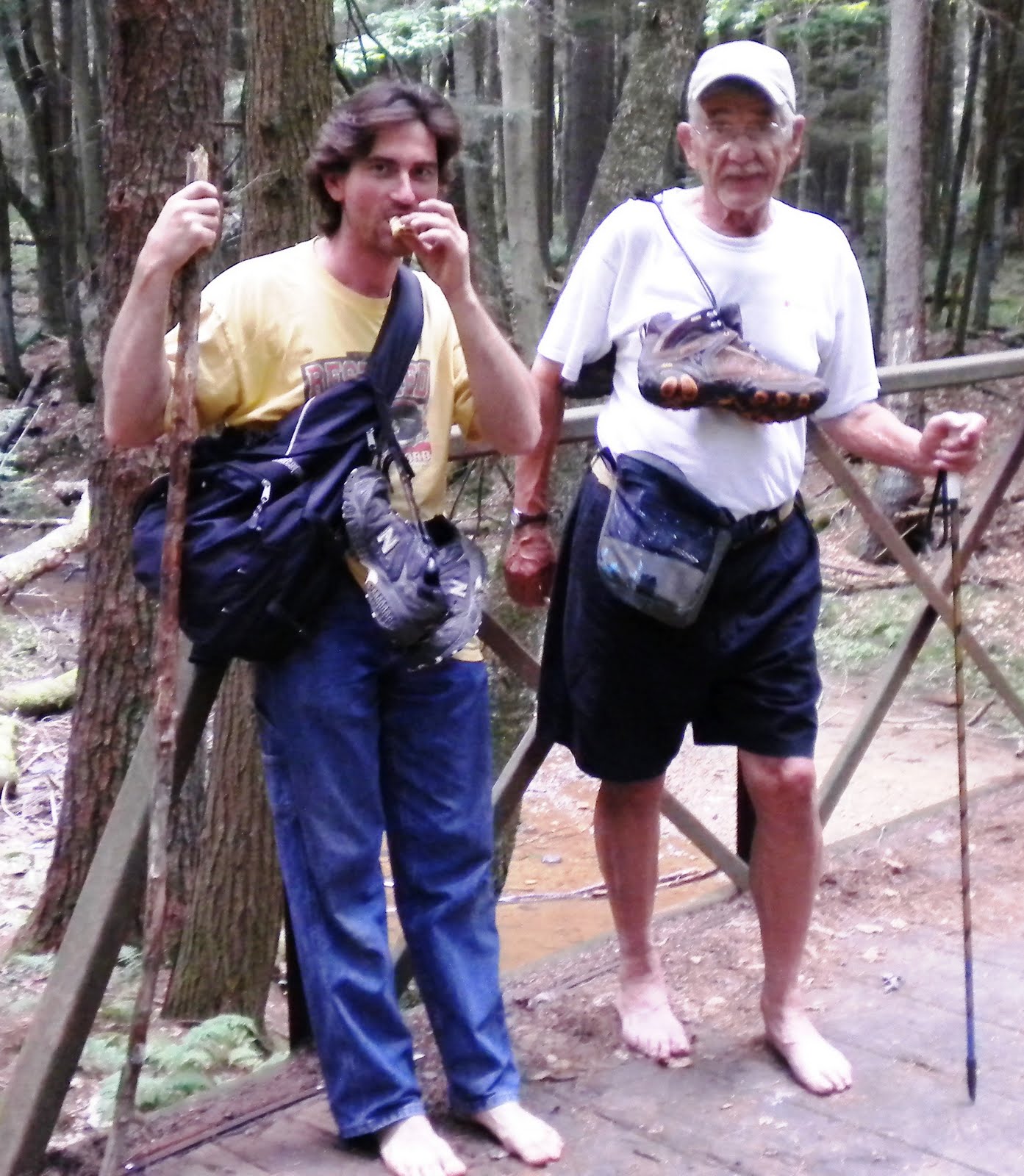
Trail through Cook Forest State Park is much wider, packed down much harder and relatively flat.  The hike seemed to go faster once the group started hiking on the trail in Cook Forest.   5 of the group reached the bridge over Brown's Run faster than Bill Wesner and Dan Ochs.  We waited for them for a little while and just as Gene Stiglitz volunteered to go back and see if they were ok, we could see them coming down the trail..... very slowly.  As they approached, we realized that they were not wearing any shoes.  We asked them what was going on and they said that they had a $10 bet on who would put their shoes back on first.  They posed for a picture (found at right) and the group pushed on once again.

The 5 in the group with shoes quickly pulled away from Bill and Dan and let them settle their bet in private.  After crossing Brown's Run, the NCT follows just above Brown's Run till it meets with Tom's Run Trail Road.  When the first of the now 2 groups of hikers reached Ton's Run Trail Road, we waited for Bill and Dan.  A few minutes later Bill and Dan arrived with shoes.  Let's just say that Bill was $10 richer and bought a few rounds later, and Dan's feet survived for a possible rematch another day.

The last part of the hike through Cook Forest State Park was a leisurely walk along Tom's Run back to the Environmental Center and our awaiting cars.  The heat of the day held off until about the last hour of the hike and everyone thoroughly enjoyed the late morning/early afternoon walk.  We arrived back at our vehicles at about 2:30.  Everyone is looking forward to the next hike.

Saturday, July 31, 2010

Trail Work Weekend November 5-7

The Clarion Chapter will be holding a work weekend November 5-7 in conjunction with the Keystone Trails Association and DCNR.  We will be working on an approximately 100 yard long wet section of trail in the Maple Creek area.

We will be creating turnpike using materials supplied by DCNR.  The wetness in this area can get very bad and this is some much needed work.  All help in this project would be appreciated.

We will have a cabin in Cook Forest for the weekend. We will be at River Cabin #1 Friday night and Saturday night.

We will be working on the project all day Saturday and part of the day on Sunday.

For more information on this work weekend or to reserve a bunk for the weekend, contact Ed Scurry at (814) 437-1168, Dave Galbreath at (814) 226-5574,  or Devin Callihan at (814) 319-5058.

August Chapter Hike Scheduled

The Clarion County Chapter of the North Country Trail Association will be having it's monthly hike on Saturday August 14th at 10:00 A.M.  We will hike from the trail head on Route 66 (N41* 25.164'  W079*12.622 ') to the Environmental Center in Cook Forest (41* 20.783' W079* 13.101').  This hike will take us through the Maple Creek area and part of Cook Forest.

This will be an approximately 8 mile hike over moderate terrain.  Transportation can be made available for anyone interested in only doing the first 4 mile section of this hike.

We will meet at the Environmental Center in Cook Forest at 10:00 A.M.  The chapter will provide transportation from here to where our hike will begin at the trail head on Route 66.

If you are interested in attending, or have any questions, please reply to this e-mail or contact Dave Galbreath at (814) 226-5574, Ed Scurry at (814) 437-1168 or Devin Callihan at (814) 319-5058.

Sunday, July 18, 2010

July 2010 Hike

The Clarion County Chapter of the North Country Trail Association held a monthly hike on Saturday, July 17, 2010.

Seven hikers headed off from the trail head at White Oak Drive at about 10:20 in the morning on what turned out to be about a 7.6 mile hike.  The original seven hikers were Dave Galbreath, Ed Scurry, Devin Callihan, Gene Stiglitz, Katie Callihan, Brian Pidgeon and Dan Ochs.

It was a beautiful, but hot and humid day in Northwestern Pennsylvania.  This section of the trail follows a path that has been thoughtfully placed on beautiful hillsides and old logging roads as it winds through relaxing conifer and hardwood forests.  Everyone reveled at the sight of the occasional interesting plant, flower, or fungi found in a forest basking in the sunlight of a mid-summers day.

After reaching Breniman Road, the band proceeded on a .7 mile road walk down the road and across the bridge over Toby Creek.  We entered the forest again on the other side of Toby Creek and began the second half of our journey.

For the first part of this section, the trail follows the hillside above Toby Creek.  Along this part of the hike, the group stopped to several times to find some geocaches located along the trail.  The trail descends again to Toby Creek and meets up with it, but does not cross it, at Game Lands Lane (a gated game commission road bisecting Game Lands 72).  The group found another geocache at this location, and took the opportunity to take a rest and a picture at the nice bridge that the Game Commission has across Toby Creek.

After this short break came the most challenging part of the hike.  The trail follows Game Lands Lane at this point, which ascends pretty rapidly from Toby Creek.  The group slowly broke apart into 2 slightly spaced out groups for this part of the walk, and the first group got a little bit of a break in the shade where the trail leaves Game Lands Lane, while waiting for the second group.

Once the hikers were all back together again and standing around talking, we were joined by another hiker, Frank Ochs, traveling towards us on the trail.  Frank joined our group as we hiked across the wide open mountaintop on Game Lands 72.  This area offered some pretty spectacular views even though it was very hot and the sun was not letting up in the cloudless sky.

At the “Duck Ponds”, the group briefly stopped to hide a geocache and then continued along the trail towards the boar farm and Rapp Run.  As we entered the forest again from the wide open hilltop, the trail follows briefly along a boar farm and the hikers kept looking to the right, through the fences, trying to catch a glimpse of a boar.  No boars today.

On the last mile or so of the hike, the group found a few more geocaches and stopped briefly to sign the trail log book located beside Rapp Run.

Our band reached the trail head at approximately 2:30 PM.  It was another great day along the North Country Trail in Clarion County Pennsylvania.

Sunday, June 27, 2010

July Chapter Hike Scheduled

The Clarion County Chapter of the North Country Trail Association will be having it's monthly hike on Saturday July 17, 2010 at 10:00 A.M.  We will hike from the trail head at White Oak Drive (N41* 17.148'  W079* 20.598') to Kiser-Wagner Road (41* 14.392' W079* 23.863').  This will be an approximately 5 mile hike over moderate terrain.

We will meet at the trail head on White Oak Drive at 10:00 A.M.  The chapter will provide transportation back to White Oak Drive from Kiser-Wagner Road.

If you are interested in attending, or have any questions, please reply to this e-mail or contact Dave Galbreath at (814) 226-5574 or Ed Scurry at (814) 437-1168.